
NASA Satellite Data Shows 2026 El Niño Surpassing Previous Climate Records
Key Takeaways
- NASA satellite data shows the 2026 El Niño is developing more rapidly than the 1997 and 2015 events.
- WMO projects sea surface temperatures in the tropical Pacific could rise 3.8°C above average through January 2027.
- The phenomenon is expected to peak in late 2026, with global climate impacts continuing thereafter.
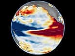
OPA WIRE, Oct 23 (OPA) — NASA has released comparative satellite data tracking the development of the 2026 El Niño, revealing a climate event that has emerged with greater suddenness than its predecessors. By utilizing altimetry satellites to measure sea level height—which expands as water temperatures rise—researchers have identified a significant accumulation of warm water pushing toward South America. This pattern mirrors the intensity of the 1997 event, which remains one of the most powerful on record.
Josh Willis, a project scientist at NASA’s Jet Propulsion Laboratory, noted that while every El Niño possesses unique characteristics, the current data suggests this event is on track to exceed the magnitude of both the 1997 and 2015 occurrences. The World Meteorological Organisation (WMO) has corroborated these findings, reporting that sea surface temperatures in the tropical Pacific could rise as much as 3.8°C above average between November 2026 and January 2027. WMO Secretary-General Celeste Saulo described these figures as being off the charts compared to the last four decades of monitoring.
El Niño is a naturally occurring climate phenomenon characterized by the weakening of trade winds, which allows warm water to pulse eastward across the Pacific. This feedback loop between the atmosphere and the ocean disrupts global weather patterns, historically triggering events such as droughts in southern Africa, wildfires in Indonesia, and coastal flooding in California. Because each event follows a different trajectory, scientists emphasize that the specific regional impacts for the coming winter remain subject to variability.
Despite the clear data trends, experts caution that the precise consequences of this year’s event are not yet fully determined. While the 2026 El Niño shares structural similarities with the 1997 event, the complexity of ocean-atmosphere interactions means that exact outcomes remain difficult to forecast. The WMO expects the phenomenon to peak toward the end of 2026, with climate impacts likely to persist well into the following year.
Subscribe to the Global Briefing
Receive our flagship executive dispatch every morning. Essential geopolitical analysis, financial benchmarks, and breaking world events delivered to your inbox.
Mohammad Karamali
Verified Wire ContributorSenior correspondent covering geopolitics, regional developments, and strategic international affairs for OPA News (Optimum Public Affairs).
Related Stories & Follow-ups
Editorial Wire Science
Nobel Prize in Chemistry Awarded to Henri B. Kagan and Kenso Soai
 Science
Nobel Physics Prize Awarded to Francis Halzen for Astrophysical Neutrino Breakthrough
 Science
Colossal Biosciences Unveils AI Platform GenoMorph to Accelerate Dodo De-Extinction Efforts
Reader Discussion
Leave a Comment
0 Comments
Owner
Editorial Oversight & Machine-Assisted Reporting
Human-in-the-Loop VerifiedEditorial Oversight & Machine-Assisted Reporting: This dispatch was synthesized and localized via OPA automated intelligence under continuous human editorial supervision.
Wire Source
This report was synthesized from Daily Mail under journalistic fair use.